Counties & Villages of Ireland
Linked information from documented source.


Sligo,a county in the province of Connaught, northwestern Ireland. It is bounded by Counties Leitrim (east), Roscommon (southeast), and Mayo (southwest); an arm of the Atlantic Ocean forms its other borders. The town of Sligo is the county seat. Nearly half of Sligo is rough pasture, predominantly in the mountains, hills, and peat bogs. On the east the boundary with Leitrim runs southward through the coastal lowland to the limestone Dartry Mountains, including Ben Bulben (1,730 feet [527 metres]), which possess spectacular scarped edges. The archaeological studies suggest that Sligo may have been one of the earliest places of human settlement in Ireland. The megalithic cemetery of Carrowmore dates back to the Stone Age and is part of a huge complex of remains connecting Carrowkeel in south Sligo to the Ox Mountains, to the Cuil Irra Peninsula, where Queen Maeve's tomb, Miosgán Médhbh, dominates the western skyline from the crest of Knocknarea Mountain.
Famous medieval manuscripts written in County Sligo include the Book of Ballymote, the Great Book of Lecan, and the Yellow Book of Lecan. The patron of the Annals of the Four Masters was Ferghal O Gadhra of Coolavin in south County Sligo. Sligo was not officially a county until after the Nine Years War, in 1603. Its boundaries reflect the Ó Conchobhair Sligigh overlordship of Íochtar Connacht (Lower Connacht) as it was at the time of the Elizabethan conquest. This overlordship consisted of the territories of Cairbre Drumcliabh, Tír Fhíacrach Múaidhe, Tír Ollíol, Luíghne, Corann and Cúl ó bhFionn. Each of these was made into an English-style barony, hence Carbury, Tireragh, Leyny, Tirerril. Corran and Coolavin. The capital of the newly shired county was placed at Sligo.

Benbulben is a majestic mountain that overlooks the beautiful North Sligo countryside known as Yeats Country. Benbulben means Jaw Peak and the mountain was shaped that way by glaciers during the Ice Age. The mountain is also the setting of several Irish legends. It is believed to have been one of the hunting grounds of the Fianna and the resting pace of Diarmuid and Grainne. Benbulben features prominently in the poetry of W. B. Yeats, after whom Yeats Country is named and County Sligo is considered integral to the poet’s work.
Probably one of Ireland's most striking mountains is Benbulben, with its height of 526m , Benbulben can be spotted from all around County Sligo. Benbulben was shaped during the ice age when Ireland was buried underneath glaciers. When the glaciers moved, they shaped the plateau into its distinct formation as we know it today. Benbulben really stands out with its distinctive large flat-top, making it into Ireland's table top mountain. It forms part of the Dartry mountains. Benbulben is home to a huge variety of plants, some of which can nowhere else be found in Ireland. Many of the plant on the top are arctic-alpine plants which are robust enough to survive the harsh climate.
Deep within the Dartry mountains is Benbulben Barite mine. Once a busy underground world used to unearth barite, the work has long halted and the mines have been closed. While the buildings are long gone, the mine has left old disused mineshaft which are too dangerous to enter (and located on private land) and old rusty pylons and wire ropes once used to transport the barite down the mountain. One of the legends surrounding Benbulben is that against the flanks of this majestic mountain, a "fairy door" can be seen which provides the fairies with an entrance to our world. And it is claimed that it is the only place in ireland where fairies are visible to mortals. Even the poet WB Yeats wrote about this famous door referring to it as a white square in the limestone.

The origins of Markree Castle date back to the 17th Century where the Cooper family acquired the Markree Castle estate under the 1662 Act of Settlement of King Charles II. At this time, it was not a castle as such, but more a fort guarding a ford on the Unshin river. By the end of the 17th Century, with Markree Castle officially now a manor, the Cooper family had become one of the biggest land owners in the country. In 1727, following the purchase of Lord Collooney’s estate, the family were presiding over 40,000 acres, with Markree Castle at its peak. In keeping with the expansion, Markree Castle at this stage was transformed from a fort into a much more comfortable manor house.
At the beginning of the 19th century, the architect Francis Johnson, a very well-known architect, was employed to extend, improve and enlarge Markree Castle. Johnson had the GPO in Dublin, the castellated gate to the Royal Hospital in Kilmainham, the chapel in Dublin castle and Charleville Castle all amongst his notable work. This major remodel and expansion are the basis for Markree Castle as it is today. In 1834, work was begun on an Observatory in Markree Castle. This included the world’s first cast-iron telescope, with the largest refractor lens in the world at the time. In 1848, a minor planet or asteroid called Metis was discovered in Markree Castle’s observatory, the first and only asteroid discovered in Ireland up until 2008.
By the early 20th Century, the land owned by the Cooper family was reduced from 40,000 acres to 5,000. This century was unkind on Markree Castle, particularly during the Irish Civil War 1921-1922, where considerable damage was done to the castle, and left virtually unused up to 1947. In the 1980’s, Charles Cooper and his wife Mary became the 10th generation of the Cooper family to live in the castle. At this point, Charles who worked in hotel management, along with his wife decided to renovate the virtually ruined castle into a hotel. In October 1990, they even had legendary singer Johnny Cash and his wife June Carter stay in the now castle hotel.
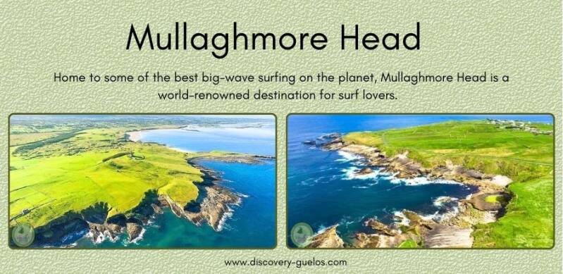
Mullaghmore Head in County Sligo is a very special place and a deserving Signature Wild Atlantic Way Discovery Point. The village of Mullaghmore is a charming fishing village with a working harbour and a beautiful sandy beach with great views of Benbulben. Mullaghmore is a famous surfing destination with some of the highest waves in Europe. It is often the venue for international surfing competitions..
Do take the opportunity to walk around Mullaghmore Head and photo opportunities are endless. Starting at Mullaghmore village walk north away from the village with the Atlantic on your right hand side. Follow the road all the way round Mullaghmore Head enjoying the views and watch out for sightings of wild birds such as Fulmars, Oystercatchers, Manx Shearwaters and Gannets. As you walk around the headland you will see the imposing sight of Classibawn Castle. This is an easy walk taking about 1 hour.

On the shores of Sligo Bay visit the recently restored Lissadell House & Gardens, which has played an integral part in Ireland’s recent history. The childhood home of Countess Markievicz, one of the leaders of the 1916 Rising, it was also a favourite place of the great WB Yeats, who drew inspiration for his poetry from Sligo’s landscape. The impressive Lissadell House, home of the Gore-Booth family, is situated outside Carney in the townland of Lissadell, 12 miles from Sligo town. Its site is a beautiful location in close proximity to the majestic table mountain, Benbulben. The House is surrounded by mature woodlands with its immediate surroundings sloping gently away towards Sligo Bay. The house was built in the 1830's for Sir Robert Gore-Booth MP by London architect Frances Goodwin. He decided to follow the fashion of large houses at the time which was 'restrained greek revival. Although impassive and forbidding on the outside the house had a more intimate and warm feel inside. This was created by incorporating large windows in the design which allowed a lot of natural light to fill its interior.
Sir Robert Gore-Booth MP left the house and estate in the capable hands of his second son, Sir Henry Gore-Booth in 1876. Sir Henry was an adventurer who had hunted big game in Africa as well as sailing his own yacht to the Arctic. Henry had been given responsibility for the estate 10 years previously, due to the death of his father’s agent and had showed himself more than adequately prepared to deal with the running of such a large holding (At that time approx. 32,000 acres). Sir Henry had five children, Constance (1868), Josslyn (1869), Eva (1870), Mabel (1874) and Mordaunt (1876). These children had the pleasure of growing up in a beautiful setting where they could roam freely and enjoy the bustling activities on the estate

In the heart of Sligo town, explore Sligo Abbey, a medieval Dominican monastery built in 1252 and destroyed by an accidental candle fire in 1414. Home to Gothic and Renaissance works of art, legend has it that its silver bell was thrown in Lough Gill and only those living sin-free lives can hear it ring. The Dominican priory known as Sligo Abbey has dominated Sligo's eastern district since the town was founded in the mid-thirteenth century. Large parts of the church, sacristy and chapterhouse are preserved from this period, alongside the beautiful fifteenth century cloister and associated buildings.
The Abbey has endured many calamities, including an accidental fire in 1414, the dismantling of a substantial wooden cross for use a battering ram during a siege at the town's castle, and violent destruction at the hands of Plantation landlord Sir Frederic Hamilton in 1642. During the eighteenth century, the now abandoned Abbey functioned as the town's main burial ground, becoming overwhelmed by the influx of victims of cholera in the summer of 1832.
Despite the ravages of history, the Abbey retains a great wealth of carvings, including Gothic and Renaissance monumental sculpture, the well-preserved cloister arcade, and the sculptured fifteenth-century high altar - one of the very few to survive in an Irish monastic church. Visitors can also explore the remains of the dining hall and dormitories on the upper floor, as well as the graveyard, which surrounds the complex.

Step back into Neolithic times on your trip to Sligo with a visit to the Carrowkeel Megalithic Site. This collection of tombs is one of the largest and most important ancient sites in Ireland, with stone structures standing here for over 5,000 years. Visitors are welcome to explore, but please don’t climb on or damage the tombs. County Sligo is home to the largest and oldest collection of neolithic stone circles and dolmens found in Ireland. The monuments, an early form of passage grave, are located at Carrowmore, a townland within an extensive landscape of prehistoric burial and ceremonial monuments at the heart of the Cuil Iorra peninsula, four kilometers southwest of Sligo town.
The Carrowmore complex is arranged around the edges of a subtle plateau at the centre of the peninsula, a parcel of undulating land with fixed boundaries, surrounded by water on all sides. Ballisodare Bay, location of the First Battle of Moytura lies to the south, the wide Atlantic ocean lies to the west; and the enclosed body of water called Sligo Bay is to the north. Lough Gill, the Lake of Brightness lies to the east beyond Carns Hill, connected to the sea by the short shelly Sligo river, the Garavogue. This almost every peak and summit in this area is capped with a neolithic monument, a later form of the passage graves found at Carrowmore. According to folklore, the monuments were believed to have been built by a cailleach named Garavogue who lives in her house in the Ballygawley mountains. The stunning cairn-topped mountain of Knocknarea rises abruptly four kilometers to the west of Carrowmore, while the smaller, but equally important Carns Hill is four kilometers to the east. There are more neolithic monuments on the summits of the Ox Mountains to the south.
Thirty monuments remain at Carrowmore today, in varying states of preservation and completion, the most perfect being the Kissing Stone. The antiquarian George Petrie noted sixty-five monuments during his visit for the Ordinance Survey in 1837, but today the number is thought to be considerably lower at a probable maximum of forty circles. The sites were badly damaged in the early years of the nineteenth century by land clearance and gravel quarrying.

It may only be a 20km drive from Sligo town, but Sligo Folk Park will make you feel like you've been transported to a completely different world. Set on the grounds of the restored Millview House, which was originally built in the 1850s, Sligo Folk Park offers an immersive experience into old rural Ireland. Wander through reconstructed village streets, cottages and a school house and explore the 12 exhibits on display. Discover bygone Irish rural life and heritage at the Sligo Folk Park, in the beautiful village of Riverstown, County Sligo. Situated 20km from Sligo Town, Riverstown is just off the M4, Dublin to Sligo motorway.
Sligo Folk Park, Riverstown, County Sligo is a community based attraction that provides a true experience of rural life and Irish heritage in the late 19th century. The Folk Park is set in the grounds of the authentically restored Millview House, which was originally built in the 1850s by George Reid, a farmer, shoemaker and church sexton. Highlights include the recreated turn of the century village street, the Hands exhibition focusing on old pastimes around the home, the school house, and the World's Most Travelled Cottage. Whatever the weather, you can stroll around the park, and visit the 12 wonderful exhibits, which house one of Ireland's finest collections of rural history, farm equipment and agricultural artefacts.


Cork is a county in the province of Munster, southwestern Ireland. The largest county in Ireland, Cork is bounded by the Atlantic Ocean (south)andbyCounties Waterford and Tipperary (east), Limerick (north), and Kerry (west). The county seat, Cork city, in the south-central part of the county, is administratively independent. Cork has long east-west ridges forming uplands and hills. Less than one-third of the area is rough pasture, and farmlands climb as high as 800 feet (245 metres) and line the valleys of such east-flowing rivers as the Blackwater, the Bride, the Lee, and the Bandon. In east and central Cork are broad valleys and lowlands, which give way in the west to narrower valleys with coastal lowlands backed by high mountains. Around Bantry and Dunmanus bays are long, scenic peninsulas such as Beare Peninsula. At the head of Bantry Bay is Glengariff, where subtropical vegetation survives because of the mild winters.

Cork is also a seaport and seat of County Cork, in the province of Munster, Ireland. It is located at the head of Cork Harbour on the River Lee. Cork is, after Dublin, is Ireland’s second largest city. The city is administratively independent of the county. Cork Harbour is one of the best natural harbours in Europe, which facilitated the founding of one of the world’s first yachting clubs in 1720. The port of Cork is divided between terminals at Tivoli on the outskirts of the city and deepwater facilities (including an automobile ferry) at Ringaskiddy. The port of Cobh is on Great Island at the head of the outer harbour. There is an international airport just outside the city. Tourism contributes to the regional economy, and the city is a gateway for visitors to southwestern Ireland. The city’s industrial base, once dominated by assembly works for tractors and automobiles, now depends on electronics, petrochemicals, and the pharmaceutical industry. The traditionally nomadic minority indigenous to Ireland known as the Irish Travellers, some 1,200 of whom live in Cork and surrounding areas, received official recognition by the national government as an ethnic group in 2017.
In 1919–20 Cork became a centre of Irish nationalist resistance to British military and police repression, and parts of the city were burned by British forces in retaliation for an ambush on a convoy carrying members of the elite Auxiliary Division of the Royal Irish Constabulary (RIC). Two of the city’s lord mayors, Thomas MacCurtain and Terence MacSwiney, both of whom were also local republican leaders, died in 1920: MacCurtain was shot dead in his bed by the RIC, and his successor, MacSwiney, died in Brixton prison after a 74-day hunger strike. Further devastation followed the conclusion of the Anglo-Irish Treaty in 1921, when Irish republican forces unwilling to accept the treaty held the city for a time.
The city has a thriving cultural life, with a municipal art gallery (the Crawford), a major theatre (the Cork Opera House), a vigorous arts centre (the Triskel), a civic museum (Cork Public Museum), and many art galleries (notably that of the Cork Arts Society) and bookshops. It is also the storehouse for the flourishing craft workers of West Cork, which is home to numerous indigenous and foreign artists and writers. The former butter market now houses a number of craft workshops, and the nearby Firkin Crane Centre is a dance development centre. The city is home to the long-established Guinness Jazz Festival. A covered market is one of Cork’s most notable attractions, with many specialty foods and examples of local produce as well as traditional meat, poultry, and fish stalls.
The burning of Cork (Irish: Dó Chorcaí) by British forces took place on the night of 11–12 December 1920, during the Irish War of Independence. It followed an Irish Republican Army (IRA) ambush of a British Auxiliary patrol in the city, which wounded twelve Auxiliaries, one dead. In retaliation, the Auxiliaries, Black and Tans and British soldiers burned homes near the ambush site, before looting and burning numerous buildings in the centre of Cork, Ireland's third-biggest city. Many Irish civilians reported being beaten, shot at, and robbed by British forces. Firefighters testified that British forces hindered their attempts to tackle the blazes by intimidation, cutting their hoses and shooting at them. Two unarmed IRA volunteers were also shot dead at their home in the north of the city.


More than 40 business premises, 300 residential properties, the City Hall and Carnegie Library were destroyed by fires, many of which were started by incendiary bombs. The economic damage was estimated at over £3 million (equivalent to approximately €150 million in 2021), while 2,000 were left jobless and many more became homeless.
British forces carried out many similar reprisals on Irish civilians during the war, notably the Sack of Balbriggan three months before and the burning of Knockcroghery six months later, but the burning of Cork was one of the most substantial. The British government at first denied that its forces had started the fires, and only agreed to hold a military inquiry. This concluded that a company of Auxiliaries were responsible, but the government refused to publish the report at the time. No one was held accountable for the burning.
Saint Augustine, who lived from 354-430 AD in Algeria, encouraged people to live together in communities bound by religion. Different communities which followed the word of the Saint, together came to be known as the Order of St. Augustine by the decree of the Pope in 1256. The Order came to Cork or Corcach, as it was then called, somewhere before the 1300. After seeing raids, expulsion and opposition over a century and half, the Augustinians, laid the first stone for the Church in 1780 and the construction was completed in 1781. The present day Church was built in 1942.


The shrine in the Church is devoted to Our Lady of Good Counsel as are other institutions that are Augustinian in origin. Every year, a feast day is celebrated on 26th April in honour of Our Lady. Along the altar, are the Mysteries of the Rosary which constitute prayers on love, devotion, peace, etc. through instances in the lives of Jesus and Mary. Designed by Gabriel Loire, the North and South Windows at this Church must not be missed. Both these windows are masterpieces of Loire’s work. The Northern window depicts the Interior Life of the Church. To the visitor, it speaks of the God as the source as well as the summit of Interior Life. It also gives the message of hope, perseverance and having faith in God.


Blackrock Castle was originally built on the Lee in 1582 by the citizens of Cork as a watch tower and fort to guard the river entrance against pirates and other invaders. In 1600 a round tower was constructed by the Elizabethan government at the request of the citizens of Cork to protect them from marauding pirates and other invaders.
Following a charter by James I in 1608, Blackrock Castle was handed over to the City of Cork. In 1722 the old tower was destroyed by fire and was rebuilt with an octagonal room topped with a cupola. The castle was used at this time as the Corporation banquet hall and for “throwing the dart”. The original fortified structure, which survives at lower levels at Blackrock Castle, is today a National Monument and probably the oldest surviving structure still in use in the city of Cork.
Titanic Experience Cobh is a visitor centre located in the original White Star Line Ticket Office in the centre of Cobh town (formally known as Queenstown), in what was the departure point for the final 123 passengers who boarded the Titanic. The visitor experience is presented in two parts. At the heart of Titanic Experience Cobh lies the personal stories of 123 men women and children, who travelled to Cobh (then known as Queenstown*) on April 11th 1912, to board Titanic bound for New York. Four days later they found themselves fighting for their lives in one of history's most tragic maritime disasters.


The picturesque Blarney Castle in County Cork, Ireland, represents the third castle on the site. The first was a timber castle built during the 10th century. In approximately 1210, it was replaced by a stone structure whose entrance was about 20 feet above the ground at the northern face. The current keep was added atop the 13th century structure in 1446.The castle was once occupied by Cormac MacCarthy, King of Munster, who is believed to have provided 4,000 men to support Robert the Bruce against the English at the Battle of Bannockburn. It is alleged Robert the Bruce gave half the Stone of Scone to MacCarthy in appreciation for troop support sent to Ireland. The stone eventually became known as the Blarney Stone, which is still located below the battlements of Blarney Castle.
Legends suggest the stone was referenced within the Bible as "Jacob's pillow" and brought to Ireland by the Prophet Jeremiah. It was more likely transported from the Holy Land during the Crusades, supporting the Stone of Scone legend. Yet another legend suggests MacCarthy was told of the Blarney Stone and its magical powers after saving a woman from drowning. The lady, supposedly a witch, told him of a secret stone in the castle that would give the gift of eloquence after kissing it. Whether legend or truth, tourists still flock to the castle for a chance to kiss the Blarney Stone and return with a fascinating story to share.


In 1646, the castle was besieged by Parliamentarians during the Eleven Years' War by Cromwell's general, Lord Broghill. After penetrating the tower walls, his men entered the keep to find only two persons. Nearly the entire garrison initially defending the castle escaped via the underground Badgers Caves, existing below the castle. During the Williamite War in the 1690s, control of Blarney Castle changed after the 4th Earl of Clancarty was captured and his lands were surrendered to the Williamites. In the early 1700s, it was purchased by Sir James St. John Jefferyes. Thereafter, his family built a mansion near the keep, which was eventually destroyed by fire in 1874. A new baronial estate known as Blarney House was constructed in its place.
One of Cork’s most distinctive landmarks, St. Fin Barre’s Cathedral is located where Cork’s Patron Saint founded his first Church and School. It is the diocesan cathedral of the Church of Ireland and the Bishop’s residence is directly opposite the cathedral gate. St. Fin Barre’s was designed by the notable architect, William Burges, who also designed the stained glass, the sculptures, the mosaics, the furniture and metal work for the interior. The foundation stone was laid in 1865 and the building was consecrated in 1870. The Cathedral is stylistically late 13th century pointed Gothic and is cruciform in shape. It has triple spires with portals to the west front and an abundance of external stone carved detail. Cork limestone and marbles were used throughout the building.


Interesting features include the high columns of the nave made of Bath stone. The walls are lined internally with Cork Red Marble. The iconographic scheme deals with the journey to the new Jerusalem and some of the best stained glass in Ireland show scenes from the Old and New Testaments. The organ, dating from 1889, is placed in the north transept. It is the largest Cathedral Organ in Ireland and the only one in a pit in Britain or Ireland. There is a canon ball dating from the siege of Cork, 1690 and there are over 1200 carvings. The Cathedral is of major international significance as one of the key buildings of Burges and of nineteenth century architecture in Ireland.
The Market was created in 1788 by the Protestant or “English” corporation that controlled the city at that time. It was a new flagship municipal market located at the heart of the new commercial city centre. When local government was reformed in 1840, and the representatives of the city’s Catholic, “Irish” majority took over, they established another covered food market, St. Peter’s Market (now the Bodega Bar on Cornmarket Street), which became known as the “Irish Market” to distinguish it from its older counterpart which remained associated with its English creators. It is thus that the name “English Market” dates from this era of transition
The economic development of Cork in the 18th century was mirrored by the physical development of the city during the same period. After the partial destruction of the city’s walls during the Williamite siege, the city began to expand rapidly in the area outside the walls and began to take on a recognizable modern configuration. The 18th century saw the reclamation of the Dunscombe and the Reap marshes, creating a land-mass that correlates with the area between Saint Patrick’s Street and the South Mall. Hammond’s marsh to the west was also reclaimed. The river channels between the marshes were infilled to form what are now Saint Patrick’s Street, the Grand Parade, Henry Street, Grattan Street, Cornmarket Street, Sheare’s Street and other streets.


As the 1780’s progressed, the regulation and control of markets was brought a major step forward by the corporation’s decision to establish a new, purpose-built, conjoined covered food market at the core of the new city centre – this was inspired by the trend developing in England of modern covered markets. During 1785 and 1786, the Corporation took a number of dwellings fronting onto the newly created Grand Parade as well as onto Princes Street where the markets were to be built, and so began the establishment of the English Market. The foundation for the Market was formally laid on September 29th, 1786 and work proceeded throughout the next two years. Several stalls were completed in July 1788 and offered for rent, paid weekly, for one year (it was specified that they were for the sale of meat only).
The grand opening took place on 1st August 1788. The newly emerging United States of America had not yet elected it’s first President, George Washington. And just months previously the first vessels of the “First Fleet”, under Captain James Cook, had arrived in a far foreign land. These vessels carried the convicts and marines who are now acknowledged as being the “Founders of Australia”.
Saints Peter and Paul's Church is a Catholic church located on Carey's Lane in Cork City, Ireland. Peter and Paul's was built to replace Carey's Lane Chapel, a much smaller structure built in 1786. Under the guidance of Archdeacon John Murphy, a design competition was run in the 1850s and won by E. W. Pugin, son of Augustus Pugin. The foundation stone was laid on 15 August 1859. Though the construction of the church was completed in on 29 June 1864, and the public were granted the opportunity to view the interior of the church at this time, the church was unable to open as the debts associated with its construction had not yet been paid off. Exactly two years after the church first welcomed members of the public to enter, it was dedicated for worship on 29 June 1866. Between 1939 and 1962, the roof of the building was renewed, and the baptistry was repaired. In the 1980s the building underwent major renovations.


Interior with stained glass, the church comprises a central main hall with gable roof and two aisles. The walls are of red sandstone with limestone dressing. The aisles are at either side of the main hall, which is covered with a gable roof. The ridge of the roof is decorated by ornamental ironwork, partly golden, terminated at the western gable by an ornamental cross with foliated arms. The grand altar is carved from 36 tons of Carrara marble. The pavements surrounding the altar, and the steps, are all of white Italian vein marble. The apse is decorated with blue and gold ceiling panels. The flooring of the church is in white and black marble. The pulpit and confessionals were carved from Russian oak by craftsmen from Leuven and Cork.


References:
-
"The battle for Cork City, August 1922 – Interview with John Borgonovo". The Irish Story. Archived from the original on 4 June 2020. Retrieved 22 May 2016.
-
Ó Riain, Pádraig (1994). Beatha Bharra (Saint Finbarr of Cork: the Complete Life). Irish Texts Society. ISBN 1-870166-57-4.
-
Moody, T.W.; Martin, F.X.; Byrne, F.J.; Cosgrove, A.; Ó Cróinín, D. (1976). A New History of Ireland. Oxford University Press. ISBN 0-19-821737-4.
-
Aughey, Arthur; Oakland, John (2013). Irish Civilization: An Introduction. Routledge. p. 69.
-
Michael A. Monk; John Sheehan (1998). Early Medieval Munster: Archaeology, History and Society. Cork University Press. p. 172.


Waterford - Oldest City of Ireland
Waterford City, Ireland (08 February 2024)
Information source linked.


Brief History of Waterford,Ireland
Waterford is derived from the Viking name Vadrarjfordr, situated on the River Suir, the area is the only Irish city to retain its Viking name, Veðrafjǫrðr which previously believed to mean either Fjord of the Castrated Rams or Windy Fjord, neither of which sounded particularly attractive. As a bi-lingual island, the Irish name used for Waterford is Port Láirge which translates in English as ‘Port of a Thigh’ with one origin story attributing the name to the tragic fate of a young prince named Rot. He was attracted to sea by sirens, the winged mythical female creatures, perhaps seeking an intellectual conversation when he is then torn limb from limb with his thigh bone washing ashore at Port Láirge.


Waterford displayed to be the hometown of Luke Wadding, a Franciscan friar in the 17th century, who established St. Patrick’s Day as a feast day to Thomas Francis Meagher, an enigmatic figure in the cause of Irish nationalism in the 19th century who later fought in the American Civil War. The tradition of firsts in the city would continue with Meagher flying the Irish tricolour for the first time in March 1848. The colours of the flag have a symbolic meaning also, the green representing the Catholic community of the island, orange the Protestant and white symbolising peace between the two communities.


Such religious tolerance is a unique characteristic of the city of Waterford with groups such as the Quakers, Jews and French Huguenots, the latter settling in the south-east of Ireland in the late 17th century. A legacy of the Huguenots comes in the form of a bread called the ‘blaa’, a doughy white bread bun being square in shape and covered with white flour. Such culinary innovations are further illustrated by the invention of the bacon rasher by Henry Denny in 1820 to the creation of the cream cracker in 1885 by WR Jacob. At one time, Waterford was the medieval wine capital of Ireland and was the head of the curve in relation to coffee culture, with John Aikenhead being the first to brew and distribute coffee in Ireland in the late 17th century.
Lishmore Castle

Lismore Castle is the Irish home of the Duke of Devonshire, located in County Waterford, Ireland, it has been significantly rebuilt over the years: the current structure dates predominantly to the mid 19th century. Originally built as a sister castle to the nearby Ardfinnan in 1185, it was closely linked to Lismore Abbey, and remained a site with ecclesiastical connotations well into the 13th and 14th centuries. It was also a strategic site, built to guard the river crossing, and was in the possession of the Earls of Desmond for much of the Medieval period. In 1589, Lismore was briefly leased to Sir Walter Raleigh, and then in 1602, it was sold to Richard Boyle, late the 1st Earl of Cork, where he made Lismore his principle seat, transforming the castle into a residence fit for an Earl – adding a gatehouse, castellated outer wall and gabled ranges. The house was damaged in the Cromwellian wars: restoration work was undertaken to make the house habitable again, but the Earls of Cork never lived at Lismore again.


Lismore Castle was part of the dowry of Lady Charlotte Boyle on her marriage to the Marquess of Hartington (and future Duke of Devonshire and Prime Minister) in 1755. The 6th Duke of Devonshire was the one to carry out major works, turning the castle into the building it is today. The style is Gothic Revival, and the noted architect A. W. N. Pugin designed large parts of Lismore, including overseeing the renovation of the old Bishop’s Palace into a banqueting hall. The castle remains in the possession of the Dukes of Devonshire today – while their primary residence remains Chatsworth, Lord Burlington oversees the running of Lismore. In 2005, the deserted west wing was transformed into a contemporary art gallery. The castle itself is available to rent for private groups, but is not open to the public,
Waterford Medieval Museum
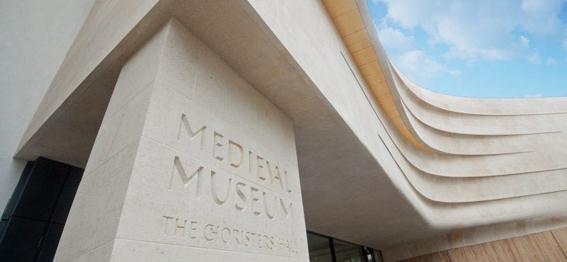
The Medieval Museum tells the story of life in Historic Waterford City and incorporates several preserved medieval structures within its walls, not least the beautiful 13th century Chorister’s Hall. Waterford city centre was excavated between 1986 and 1992 and all the unique discoveries were housed in The Museum for everyone to see. The Museum was opened to the public on Friday 24th August 2012. Among the exhibits on display are the 4m-long Great Charter Roll dating from 1372, which was viewed by Queen Elizabeth II during her historic visit to Ireland, and the 15th century cloth-of-gold vestments one of Ireland’s finest late medieval treasures.


The Dalmatic vestment is one of the most important pieces from the set of Waterford vestments on display at the new Medieval Museum, Cathedral Square. The amazing Chorister’s Hall survives from the medieval period and is one of the centrepieces of the new Medieval Museum. A wonderful depiction of King Edward III of England fully armoured and on horseback, can be seen at the museum. From preserved vestments to art, the collection is extensive. One of the more remarkable finds in the Museum is a hat belonging to King Henry VIII which was a gift to the Mayor of Waterford William Wyse in 1536.
House of Waterford

The House of Waterford crafted since 1783, Waterford continues to be at the forefront of exquisitely designed and expertly crafted crystal creations. House of Waterford stands proudly as Waterford’s flagship store and showcases Waterford’s key values of craftsmanship, allowing visitors to experience the beauty of Waterford from initial concept to final product. The Waterford Crystals of today can be traced back the time of Bernard Fitzpatrick visited Charles Bacik shortly after World War II ended, in January 1946, and secured special permits to visit again in May. This time Bacik, his family home taken over by the USSR Armed Forces and his factories nationalised, accepted Fitzpatrick's proposal to restart glassmaking in Waterford, and they agreed on the organisation of the factory, with Bacik to secure key staff, and Fitzpatrick a site and permissions. Fitzpatrick agreed a location at Ballytruckle, by Waterford's greyhound track and a soccer ground with the City Manager, and shared the plans with the Department of Industry and Commerce.


Its founders were brothers George and William Penrose, important developers and principal exporters in the city. Their vision was to "create the finest quality crystal for drinking vessels and objects of beauty for the home." More than two hundred years later, the reputation they established for creating luxury crystal of unsurpassed beauty and quality has transcended the intervening centuries.
Reginald's Tower

Reginald’s Tower is Waterford’s landmark monument and Ireland’s oldest civic building. It has been in continuous use for over 800 years. The first tower on the site was built by Vikings after 914 and formed the apex of the triangular settlement, an area known to this day as the Viking Triangle. Re-built by the Anglo Normans in the 12th century the top two floors were added in the 15th century. Until about 1700 the tower was the strongpoint of the medieval defensive walls that enclosed the city. When the Anglo-Normans attacked Waterford in 1170, the tower was of strategic importance and its capture heralded the fall of the city. This impressive structure which derives its name from the Hiberno-Norse, ruler of the city, Ragnall MacGillemaire, who was held prisoner by the Anglo-Normans in the tower.


The tower now houses an exhibition on Viking Waterford and is managed by the Office of Public Works. Some of the greatest Viking treasures in Ireland are on display in Reginald’s Tower, including the stunning Kite Brooch, the Viking Warrior’s sword, dog collar and the decorated face weight. It’s also possible to see a cannon ball stuck in the external wall. The cannon ball dates from the siege of Waterford by the army of Oliver Cromwell in 1650 when ships on the River Suir bombarded the city with cannon fire. A similar cannonball is on display on the top floor of the tower. Reginald’s Tower is the first in the chronological series of Waterford Treasures Museums and one of the key visitor attractions in Ireland’s Ancient East.
Ballysaggartmore Towers

Ballysaggartmore Towers are imposing gothic style buildings situated near Lismore in pleasant woodland walking and picnic areas. The magical towers provide a fairy tale setting which does not reflect the sad period in Irish History where extravagance and starvation lived side by side.They were constructed for an Anglo Irish Landlord, Arthur Keily-Ussher no later than 1834. He held an estate of approximately 8000 acres, the majority of which was rented to tenant farmers but he retained approximately 1000 acres as a personal demesne. Arthur Keily-Ussher inherited more than eight thousand acres of land in County Waterford. He left Ireland for a time to fight in the Napoleonic Wars, and on his return he built a relatively modest house in the grounds of his Ballysaggartmore estate. However, at some point in the 1830s, he decided that the house was not grand enough for his needs or reputation, certainly not when compared with Strancally Castle. Strancally Castle is a country house in County Waterford, Ireland. It is located on the River Blackwater, close to the town of Youghal in County Cork.


It was at this point that the Kiely-Ussher’s ambitious plans started to unravel. quickly ran out of money, and it rapidly became clear that their dream of living in the grandest house in all Waterford was just that – a dream. Thwarted in their ambition, the couple were forced to live in the existing dwelling. We can only imagine how despairing and humiliated they must have felt at the realization that the impressive carriageway and gate house they had built would never lead to the mansion that they dreamt of. This monetary crisis coincided with the onset of the Great Hunger. This terrible Famine was without doubt one of the most devastating events in Irish history. Like so much of the country, the population in Waterford dropped by more than fifty percent between the years 1841-51. Looked at in the context of these terrible times, the profligate plans of the Keilly-Usshers seem almost unbelievably crass and divisive.
Kilmacthomas Viaduct
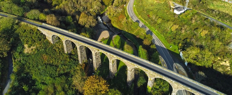
The Kilmacthomas Viaduct dates back to 1878. In the past, it was used for the transit of goods by rail. Closed in 1982, it is now a visitors’ attraction. It’s a fine example of 19th-century construction. The viaduct takes the form of 7 rubble stone arches. Constructed from limestone blocks, it combines arches, voussoirs and parapets, giving it a massive, solid and timeless appearance. Seven-arch rubble stone railway viaduct over road, opened 1878, with single-span section to centre. Closed, 1982. Squared rubble limestone walls with batter to north-west, cut-stone stringcourse, and cut-stone coping to parapets. Series of seven round arches on squared rubble stone piers having rusticated cut-stone stringcourses to springs of arches, dressed rubble limestone voussoirs, and squared rubble limestone soffits having traces of lime render over. Single cast-iron span to centre on cast-iron girders having lattice supports with sections of replacement tubular iron railings, c.1950, over. Freestanding railway signal, c.1950, to north-west.


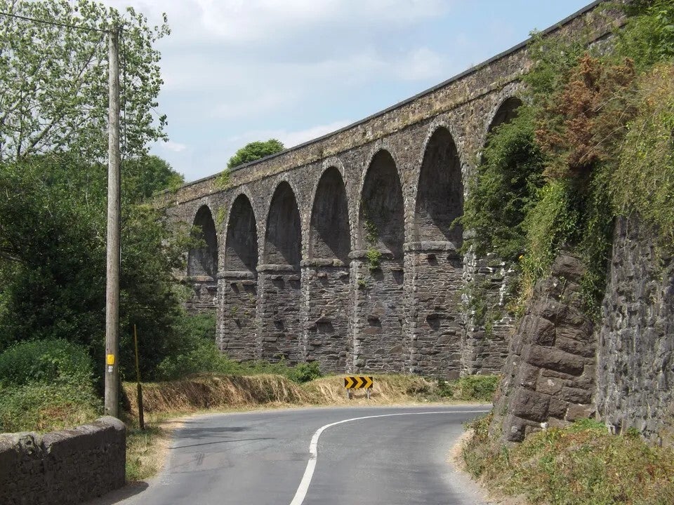
An elegantly-composed railway viaduct, built to designs prepared by James Otway (1843 - 1906) by Smith Finlaysaon and Company, Glasgow, which forms an imposing landmark in the centre of Kilmacthomas. The civil engineering heritage significance of the composition is identified by the form and construction of the arches, which have retained their original profile, together with the central span incorporating early cast-iron work. The construction in squared rubble limestone attests to high quality stone masonry, and produces an appealing textured visual effect in the landscape. The viaduct, one of a pair in the immediate locality (with 22805035/WD-15-05-35), is of particular significance as a reminder of the development of the Great Southern and Western Railway line by the Waterford, Dungarvan, and Lismore Railway Company in the late nineteenth century, which promoted the economy of smaller urban areas, such as Kilmacthomas.
Dunmore East

Dunmore East is a treat for everyone and a must to visit. The fishing village which is on the mouth of the Waterford Harbour is in the barony of Gaultier which translated from Irish means ” Land of the Foreigner”. Dunmore or Dún Mór, which means “Great Fort”, got it’s name because of a peninsula fort that was built there in ancient times.


The village was always a fishing port not only on the estuary but also out at sea and the coves offered protection from any storm that would hit. In 1812 it was decided to build a protective harbour but this was not for the fishermen but for the steam packet ships of the Royal Mail. The harbour was designed by Alaxander Nimmo but by 1937 the harbour began to silt up and the steam packet was transferred from Dunmore East to Waterford city. But it was the building of the harbour that meant that fishing could flourish and flourish it did. Today Dunmore East is not just a fishing village but a massive attraction for water sports enthusiasts, boating and sailing, fishing, walking, food and adventure.
Ardmore Cathedral Ruins

Ardmore Cathedral is located on the site of St. Declans Monastery and was formally recognised as a Cathedral in 1170. A Recorded Monument it was first constructed by Meolettrim O Duibh-rathra sometime before his death in 1203. It has undergone several phases of construction over the centuries and the present building is of various periods and styles. The chancel is the oldest part of the cathedral dating from the 9th century, with the nave being late 12th-century work. Further works on the south side-wall and the east gable are of the 14th century. The most unusual feature is the arcade – a series of sculptures on the outside of the west wall telling stories from the bible. Many of the upper panels are worn, but you can just make out the Archangel Michael weighing the souls.


Around Ardmore and its venerated founder centered one of the much-vexed questions of Irish ecclesiastical history, viz. – the date of St. Declan’s mission. The question is now, thanks to the scholarly labours of Dr. Todd, practically set at rest. Instead of a predecessor of the National Apostle, as Dr. Lanigan and his school would make St. Declan, the latter is now more generally regarded as the 6th century contemporary of St. David of Wales. But this is merely by the way. The immediate concern is not with disputed questions of’ ‘chronology but with the remains still existing at Ardmore. The latter comprise the Cathedral and its Round Tower, the primitive oratory known as “Relig Deglain,” or St. Declan’s Grave, and the church by the cliff, commonly called Dysert Church. To the foregoing-list of monuments ought to be added the Holy Well near the ruin last mentioned and St. Declan’s Stone on the beach beneath the village.
Sources:
Waterford City and County Council website.
Discover Ireland
Discover Ireland Vacations
Thank you for the video owners.


Cong, County Mayo
County Mayo, Ireland
Linked information source

In County Mayo, a town village Cong in Irish Gaelic term Cúnga Fheichin, meaning Saint Feichin’s narrows, reveals much about the geography of the area. The village is built on a narrow strip of cavernous limestone between Lough Mask and Lough Corrib. There is no trace today the remains of the monastery that Feichin founded in the 7th century. Cong Abbey, the ruins of which are in the centre of the village, was first built in the 12th century, burned in the early 13th and rebuilt between the 13th and 16th centuries. From the abbey grounds, a footbridge spans the river, passing the monk’s fishing house probably built in the 15th or 16th century, fish would have been an important part of the monks’ diet. This small house is built on a platform of stones over a small arch that creates a passage for water to flow under the floor. A trapdoor in the floor may have been used to allow a net to be cast into the river, and a fireplace kept the monks warm while they waited for their catch. It is said that a line was threaded from the fishing house to the abbey kitchen, to alert the cooks when there were fish to be cooked.
Cong is also popularly known for its location in the John Wayne and Maureen O’Hara movie, The Quiet Man, but real standout is the 12th century Augustinian monastery, a place of worship and learning until King Henry VIII disbanded all monasteries. One can easily imagine a procession of psalm-chanting monks winding past the ornate stone carvings of the Market Cross with their beautiful Cross of Cong, a gold, bronze and crystal ceremonial crucifix now held in the National Museum. Across the river is the Cong Forest Nature Trail in the monks’ woodland, which was enhanced with redwoods, giant sequoia and Monterey pine by Arthur Guinness (Lord Ardilaun) in the mid-19th century when he owned nearby Ashford Castle.
Cong is the home of Ashford Castle, a luxury hotel, which was converted from a Victorian unreal lakeside castle, built by the Guinness family. Ashford Castle is a tourist attraction in its own right. Cong also features a ruined medieval abbey, Cong Abbey, where Rory O'Connor, the last High King of Ireland, spent his last years. It also is the origin of a piece of Celtic art in the form of a metal cross shrine called the Cross of Cong.
As you walk along the dry canal revives memories of the great Irish famine of 1845-1848. The canal was a famine relief scheme that never quite fulfilled its promise in any sense of the word. At completion of the project, because of the limestone terrain, the water disappeared immediately into the ground like water gushing down the plug hole of a bath. The Market Cross on Cong’s main street is the first historical feature you encounter in the centre of the village. The decorated limestone cross is said to mark the completion of the Royal Abbey of Cong in the 12th century.
The Cong Canal, built over five years by the Commissioners of Public Works between 1848 and 1854 as a combined scheme to provide navigation, drainage and mill-power. In 1854 the Commissioners abandoned the navigation aspect of the scheme and instructed Samuel Roberts, their engineer, "to suspend the execution of all navigation works in this division of the district, and complete only such as were necessary for the regulation of the waters of Lough Mask, for drainage purposes." Now it is commonly known as the "Dry Canal", the water level can vary between zero and 3.5 metres depending on the time of year (summer dry, winter full) and is 5 km in length and built heritage features of the canal remain.


The City of Dublin, Ireland
Dublin is the capital of Ireland and in Irish term “Dubh Linn”, Norse Dyfflin or “Black Pool”, and also called Baile Átha Cliath or“Town of the Ford of the Hurdle”. Dublin is located on the east coast in the province of Leinster, set at the head of Dublin Bay of the Irish Sea. Dublin is the country’s paramount port, centre of financial and commercial dominion, and centre of culture. It is also a city of differences, maintaining an anxious relationship between reminders of earlier political and economic conditions and symbols of present-day life and prosperity.
Dublin is a very warm and friendly city, and noted for hospitality of its people and well-known for its craic or “crack”— that blends wordplay, humour, cleverness and sharp and devaluing insight that has enticed writers, intellectuals, and visitors for centuries. About one-quarter of the residents of the Republic of Ireland live in the Metro Dublin urban area, providing a good deal of hustle and bustle. The main city is divided into north-south by the River Liffey, with O’Connell’s Bridge connecting the two sections. The pubs or bars, where much of the city’s social life is led, coffee shops and restaurants brimming, and Irish tunes and music hardly allows quietness ambiance. The north section, close to the General Post Office (GPO), where most of the Georgian houses left remaining, built in the 18th century, now standing beside with the modern offices and residential apartments. The Ireland’s national theatre, the Abbey, is just east of O’Connell Street, noticeably since 2002 by the iconic Spire of Dublin, a 394-foot (120-metre) stainless steel landmark that declared the street’s changes with a pedestrian square and tree-lined thoroughfare. Even though Dublin has gone through many transformations, and in some areas—such as the narrow streets of the Temple Bar area west of Trinity College—regularly hold to wild and loud pub-goers, a strong sense of history and of a centuries-old capital diffuses.
The geographic location of Dublin is marvelous, positioned at the head of a beautiful bay, and the city links the River Liffey where it splits eastward through a hill ring-shaped plain to the shores of the Irish Sea, and the dark marsh water draining into the river made the “black pool” that gave the city its name. Almost undoubtedly, this opening from the sea—leading through the mountains to the fertile central plains of Ireland—originally attracted Viking raiders and Norse settlement. Each year the suburbs just beyond into the countryside, into the south, a natural limit posed by the Dublin and Wicklow mountains, which echo the city and provide some of its most beautiful panoramas.
Dublin acted a foremost role in the cultural renaissance that began in 1884 with the establishment of the Gaelic Athletic Association (Cumann Lúthchleas Gael) for the restoration of historical Irish games. It was expanded in 1893 with the foundation of the Gaelic League (Conradh na Gaeilge), which promotes the Irish language and Irish folklore. The National Gallery, the Irish Museum of Modern Art, the Project Arts and City Arts centres, and many privately owned galleries exhibit the liveliness of the visual arts in Dublin. Temple Bar has been developed with a mix of boutiques, galleries, and studios. At the centre of Ireland’s rich Anglo-Irish literary, philosophical, and political history, Metro Dublin was the birthplace of three winners of the Nobel Prize for Literature: playwrights Samuel Beckett and George Bernard Shaw and poet William Butler Yeats. Other prominent figures associated with the city include the satirists Jonathan Swift and Brendan Behan, the poet and dramatist Oscar Wilde, the playwright Sean O’Casey, the political theorist Edmund Burke, and the novelist James Joyce, author of the well-known short-story collection Dubliners (1914) and of the groundbreaking novel Ulysses (1922), which presents a day in the life of Dublin in 1904 through three characters whose stories analogous events in Homer’s Odyssey and in recent times, Dublin has provided the background for the fiction of Maeve Binchy and Roddy Doyle.
In the beginning of prehistoric times people have inhabited in the area around Dublin Bay, and four of Ireland’s five great roads joined near the point called Baile Átha Cliath, the name stamped by Dublin’s postmark. The city’s noteworthy resurgence began at the end of the 17th century, when thousands of refugee Huguenot weavers from France settled in Dublin after the revocation of the Edict of Nantes, in 1685, limited their rights. Flemish weavers came in their wake, and soon the cloth trades were thriving. It was not long before Dublin’s competition with English cloth interests driven the British Parliament to impose export restrictions. In the road of the 18th century, economic prosperity led to the development of Georgian Dublin. Growth extended beyond the old medieval walls; more bridges were built over the Liffey; and superbly the new suburbs arose to the north and east. The city that emerged was fundamentally the Dublin of today.
Source: The Britannica, March 2023 Updates
Discovering Ireland.com
June, 2023(NJ)

About Ireland by Ireland.com
Video courtesy and thanks to Exploropia
Glimpses of Dublin City


